Terminology (our suggestions)
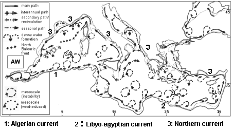
Eddies are phenomena generated either by
processes that destabilise alongslope currents (such as the Algerian
or the Libyo-Egyptian Currents), or by the wind stress curl locally
induced by orographic effects (e.g. Ierapetra and Pelops). They are characterised
as cyclonic / anticyclonic, not constrained by the bathymetry and
can progagate. Eddies are mesoscale (some 10s to a few 100s km)
features that will be characterised as small (up to ~50 km), medium (50-150
km) or large (150-250 km).
Gyres are circulation features induced by wind and/or
thermohaline forcing and/or topographic features (such as straits) that
are clearly constrained by the bathymetry (at basin and subbasin
scales), and thus they do not propagate. They are characterised as clockwise
in the Alboran (mainly due to the orientation of the Strait of Gibraltar)
and everywhere else as counterclockwise (due to the Coriolis effect).
Parts of the gyres can be unstable.
Straits are narrow passages a few 10s of km wide: straits
of Gibraltar, of Messina ...
Wider ones are all channels: channels of Sardinia,
of Sicily, of Otranto...
-
Sea, basins and subbasins:
There used to be the Mediterranean Sea, the Western Mediterranean
Sea and the Eastern Mediterranean Sea, and other seas such as
e.g. the Western and Eastern Mediteranean Seas, the Ligurian Sea, the
Tyrrhenian Sea, the Aegean Sea...., co-existing with basins such
as the western (resp. eastern) Mediterranean basin, the Liguro-Provencal
basin, the Algerian basin or the Levantine basin, and passages such
as the Cretan passage.
We propose :
- to restrict the use of the term "sea" to THE Mediterranean
Sea
- to restrict the use of the term "basin" to the western and
eastern basins of the Mediterranean (Sea)
- to call other (smaller) entities "subbasins": Tyrrhenian
subbasin, Algerian subbasin... Note that this has also the advantage of
providing clear and coherent meaning to the expression basin / subbasin
scale.
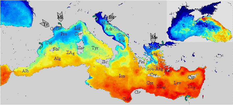
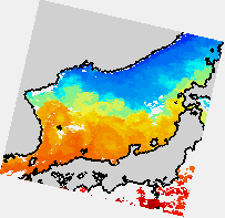
The Mediterranean Sea geography
(superimposed on the Sea Surface Temperature monthly composite image of
January 1998, from DLR). The counter-clockwise circuit of the Atlantic Water
entering through the Strait of Gibraltar is illustrated by the continuity
of the warmer (red colors) temperature alongslope.
The Mediterranean Sea is divided into the western and eastern basins.
Basins are divided into subbasins (following the AW circulation) :
Alb: Alboran; Alg: Algerian; Tyr: Tyrrhenian;
Ion: Ionian; Cre: Cretan: Lev: Levantine; Sou-Aeg:
South-Aegean; Nor-Aeg: Nor-Aegean; Sou-Adr: South-Adriatic;
Nor-Adr: North-Adriatic; Lig: Ligurian; Pro: Provencal;
Cat: Catalan.
SigmaAE, SigmaLW and SigmaLE
are areas where eddies tend to accumulate and interact, up to merging and/or
decaying, in the east Algerian, west and east Levantine subbasins, respectively.
Bal: Balearic Islands; Sar: Sardinia; Sic:
Sicily; GoS: Gulf of Syrte; Cir: Cirenaica; Cre: Crete;
Cyp: Cyprus; Rho: Rhodes; Pel: Peloponnese; Cor:
Corsica; GoL: Gulf of Lions.
The main wind systems are indicated with wide grey arrows: Tr:
Tramontane; Mi: Mistral; Bo: Bora; Me: Meltem.
Curved green arrows represent the main river outflows.
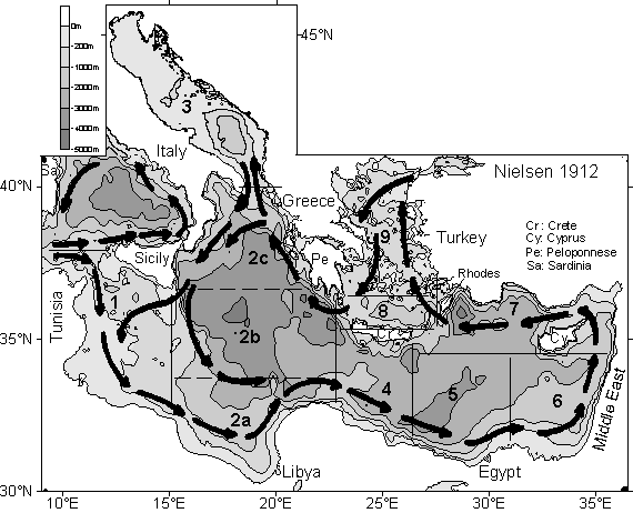
Schematic limits of the subbasins in the eastern basin:
Index of subbasins: 1:
Channel of Sicily, 2a: southern Ionian, 2b: central Ionian, 2c: northern
Ionian; 3: Adriatic; 4: southern Cretan; 5: western Levantine (deeper than
3000m: the Herodotus trough); 6: southeastern Levantine; 7: northern Levantine;
8: northern Cretan; 9: Aegean.
We see similarities between the eurafrican mediterranean sea
and the asian mediterranean sea (East/Japan Sea). 
- Millot (1992): Are there major differences between the largest Mediterranean
Seas? A preliminary investigation. Bull. Inst. Oceanogr. Monaco, 11, 3-25.