THE EGYPT EXPERIMENT
(Eddies[1] and GYres[2] Paths Tracking)
Doc. 01 July 2004/DRAFT! itaupier@ifremer.fr
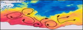
The aim of EGYPT is to investigate the circulation of the water masses in the eastern basin[3] of the Mediterranean, in order to validate the new schema of the circulation based upon the analysis of infrared satellite imagery and the few in situ data available (Hamad et al., 2004; Millot and Taupier-Letage, 2004), and backed by the results of modelling (Molcard et al., 2002 ; Alhammoud et al., 2003 ; Béranger et al., 2003b links on the web??).
The strategy is to combine both observations (in situ and remote sensing data) and model simulations, to be complemented by process studies for improved understanding.
EGYPT integrates several projects (partly due to scattered and low-level funding sources):
Ø EGYPT-P: proposal submitted to the French national program PATOM (formerly called BOMOMO: BOuées dérivantes et MOdélisation en méditerranée Orientale, and submitted in dec. 2003).
Ø EGYPT-MC: proposal submitted to the French national program GMMC (mar. 2004), to support the EGYPT-P proposal (!)
Ø EGYPT-1: proposal for shiptime on the French RV Le Suroit
Ø name? Collaboration with institutes of Alexandria NIOF and AUDO/ Egypt (country!)
and is related to / is willing to collaborate with/ the projects:
Ø MFSTEP/MEDARGO: PROVOR lagrangian profilers in the Med.(P. Poulain/OGS)
Ø MSFTEP/VOS-XBT : XBT transects in the eastern basin.
Ø name? Hydrology in the Channel of Sicily with the Tunisian RV Hannibal (C. Sammari, INSTM)
Ø name? Hydrology in the Channel of Sicily with Italian RVs (ISMAR/CNR, St. Zool. Mazara del Vallo)
Ø name? ONR Proposal for drifting buoys (P. Poulain/OGS)
Ø +?
Names of project and contact, links on the web??)
1. Brief update on the outcome of the various projects:
1.1.
EGYPT-P:
The aim is to test the results that we have recently obtained on the surface circulation in the eastern basin of the Mediterranean, as deduced from the analysis of infrared satellite images and modelling, by means of collecting appropriate in situ measurements and confronting them to the products issued from MERCATOR PAM/PSY2.
Funding was requested mainly for the observational side, the main action consisting in releasing drifting buoys in the 2 key-places that are the Channel of Sicily and the and the southern part of the Levantine subbasin[4] (off Egypt mainly).
Proposal: budget requested
|
BUDGETS |
Year 1 (6 months in 2004) |
Year 2 (2005) |
|
Consummable |
3 000 € |
1 000 € |
|
ARGOS |
(45 800 €) not included |
idem |
|
Travel |
4 500 € |
3 000 € |
|
Équipement |
24 000 € (20 buoys +
drogues) + 1000 € (transport) |
|
|
Yearly budget |
32
500 € |
4 000 € |
|
Total |
36 500 € |
|
The review was positive. However, we were alloted a funding of 25 000E (to be used entirely in 2004!), which roughly corresponds to the budget required for the drifting buoys, and we were strongly encouraged to submit a proposal to the GMMC for the complementary funding…
Basically the same as EGYPT-P, with the addition of the deployment of PROVOR lagrangian profilers, and a extended comparative analysis data-models.
Proposal: budget requested
|
BUDGETS |
Year 1 (2004) |
Year 2 (2005) |
|
Consummable |
5 400 € (includes shiptime) |
7 900 € (includes
shiptime) |
|
Costs ARGOS Not included |
4 000 € pour les 5 PROVORs |
8000 € pour les 10 PROVORs |
|
Travel |
5 150 € |
9 550 € |
|
Equipment Not included |
5 PROVORs
+ 24 XBTs T7 |
5 PROVORs+
24 XBTs T7 |
|
Yearly budget |
10 550 € |
17 450 € |
|
Total |
28 000 € (+ 10 PROVORs/loc. ARGOS + 48 XBTs T7) |
|
The review was a priori positive, but we did not get any official document yet. We have been told that we got a funding of 4 400E only for 1 year (we will have to re-submit for 2005), and obtained 5 PROVOR profilers (which will be available in 2005).
Ø
EGYPT-1:
We requested few days of shiptime in order to set in place a mooring network in the southern Levantine (subbasin), during the 1st semester of 2005. The idea was to record current time series 2-year long, and to have a large multi-disciplinary campaign in 2007, upon the mooring recovering. Although the review looks very good, the campaign was not selected.
Ø The collaboration with the institutes of Alexandria (NIOF and AUDO)/ Egypt (name?) is under examination.
Ø The monitoring of the Channel of Sicily with regular hydrological transects (name?) on the tunisian side (INSTM) is being initiated this month.
Ø We got the excellent news that Karine BERANGER has obtained a definitive position at ENSTA/Paris: congratulations!
Ø P.M. Poulain has been encouraged to submit his proposal for drifters to ONR.
More??
2. Consequences and priorities:
The low budget and its timing have serious consequences.
Priority has to be given to the operations at sea, and the funding obtained will be used especially (if not totally) for:
· the purchase of the drifting buoys,
· the shipment of the drifting buoys and PROVORs
· the travel funds to attend the cruises to deploy the drifters
As much as possible we will try to fund travel for best communication, but it looks like we are going to have to increase our use of the teleconference facilities… and more likely of the web!
Please consider that we will have to re-submit a proposal for funding in 2005 (funding which will come at best in mid-2005…), so that there is some hope left yet.
In case these restrictions are a serious problem for your contribution as exposed in EGYPT-MC and EGYPT-P (I mean a really-deadly-serious problem!!!) please warn me as soon as possible.
3. Tentative schedule of operations
3.1. Channel of Sicily:
This is the only place where we can start operations by 2004.
3.1.1. Shiptime/ Hydrology
The acquisition of hydrological sections across the Channel of Sicily (Cap Bon –Marsala) is of the utmost importance for our understanding of this area. The geostrophic currents computed could be used, together with satellite images, to define the deployment strategy of the drifting buoys on the return trip. One concern is to get transects as close as possible in time on both the Italian and Tunisian sides of the channel: we have to identify the respective contacts to achieve the best coordination possible.
· The INSTM (Cherif SAMMARI) initiates/continues the regular monitoring of the Channel of Sicily (but the Italian national waters part) with hydrological (CTD) transects (RV Hannibal). Starting this summer with a monthly frequency (correct?), this is the opportunity to launch the drifting buoys in that region. It seems that few days would even be available early November 2004 for that specific purpose? Cherif could you provide a schedule please?
· The CNR-ISMAR (Gian Pietro GASPARINI, or another contact?) organises 2 cruises/year with RV Urania to maintain moorings (correct?). As briefly discussed during the CIESM, would it be possible to make the Italian side of the hydrological transect? And could you please provide a schedule?
· The CNR-IRMA (Fabio FIORENTINO, or another contact?) is expected to be able to perform the Italian side of the transect at dates close to those of the Tunisian side, from Marsala as far as the international waters, possibly extending offshore over 1 or 2 Hannibal stations. Would it be also possible, at least in principle, to use one of this transect to launch drifters?
Who would like to /can
take in charge the coordination of the hydrological transects i) of the Italian
side ii) with the Tunisian side (Cherif SAMMARI) ?
3.1.2. Drifting buoys
· The INSTM has 5 drifters: of which type are they (depth of the drogue? additional sensors?) If we are to take in charge the costs of ARGOS location it seems that the best would be a deployment in 2004. Cherif, what are your plans/possibilities?
· The OGS (Pierre-Marie POULAIN) has already 9 CODE drifters, which might be launched before the end of 2004. CODE (surface) drifters are preferred in this area to minimize the risks in the shallow and complex bathymetry. Pierre-Marie will also submit very soon a proposal to ONR for additional drifters. Part of these deployments would be made on a seasonal basis, till the winter of 2005 (Pierre-Marie please comment/correct as needed)
3.2. Levantine subbasin :
Due to the budget limitations we do not plan any work at sea in 2004. A key point for the operations in that area is going to be the shiptime availability. We need shiptime to conduct hydrological measurements (CTD, and XBT possibly), deploy the drifting buoys and the profilers PROVOR, and set in place moorings, carrying either autonomous CTD (CIESM initiative to monitor the long-term hydrological trends) or currentmeters (EGYPT).
3.2.1. Shiptime
· The proposal for a campaign of few days on a French RV in 2005 has not been selected. We have decided thus to re-apply next year (that is early January 2005) for shiptime in 2006 on the same 45m ship (RV Le Suroit) with the same objectives, but to ask for a longer period in order to perform CTD transects too (especially deep casts in eddies). Provisionally referred to as: Cruise EGYPT-06-1.
· With our Egyptian colleagues from the AUDO and the NIOF we are currently in the process of establishing a formal agreement to collaborate in the EGYPT actions planed in the Levantine, which possibly will include shiptime.
· We have been recently alerted about the possibility to put a late proposal for the 25-m long CNRS ship for a few weeks in 2005. This has yet to be confirmed.
3.2.2. Surface drifters
The drifters used there will be of SVP type (drogue at ~15m). Deployments will take place in 2005 (potentially partly also in 2006 for the ONR drifters). The strategy is to launch the drifters along a transect westward close to the Libyo-Egyptian border (~25°E), in order to have them drift as long as possible off Egypt. Seeding drifters in an eddy is also considered.
3.2.3. Profilers PROVOR
Besides the PROVOR deployment in the framework of MEDARGO, 5 PROVOR will be deployed in 2005 in the Levantine.
3.2.4. Hydrology
Hydrological data collection is critical in the coastal zone to sample the alongslope circulation, and requires a sampling pattern coherent with the mesoscale phenomena. However it is conditioned by the availability of shiptime, mostly unknown presently. In the meantime, XBT data from the VOS_MFSTEP relevant sections can be used.
…
Other issues to be discussed later:
* the availability, processing and organisation of the analysis of the satellite data (at least for IR, and, hopefully, for VIS too. Altimetry is handled by Detlef, is that correct? )
* a dedicated EGYPT web site (who could/would help??)
* suggestions?